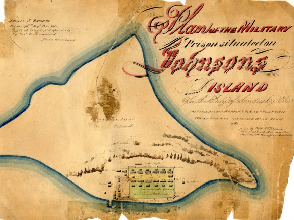
Plan of the Military Prison Situated on Johnson’s Island (Map)

- Creator: J. T. Hogane
- Title: Plan of the Military Prison Situated on Johnson’s Island (Map)
- Description: Hand-drawn color map of the military prison at Johnson's Island in the bay of Sandusky, Ohio, where captured Confederate officers were held. Prison buildings and grounds are labeled. Drawn by Capt. J. T. Hogane, Topographical Engineer, C.S.A., Gen. M. Jeff Thompson's Division. In upper left corner: "James S. Brown, Major 46th Regt. Tenn. Vol., Capt'd at Island No. 10 April 8, 1862 By Genl Popes command. Block 2, Mess 2, Room 1."
- Historical Note: Capt. James T. Hogane entered the service in August 1861. He was Brigade Engineer 1st District Missouri on staff of Brig. Gen. Thompson ("Co. Sappers & Miners"). He was captured on March 1, 1862, at New Madrid, Missouri, and came to be confined at Johnson's Island. He evidently used his talents to draw maps of the prison for various soldiers, such as James S. Brown. His handiwork is also seen at the front of St. Clair Morgan's Autograph Album in the Samuel Dold Morgan Papers, Tennessee State Library & Archives.
- Institution: Tennessee State Library & Archives
- Publisher: Digital Initiatives, James E. Walker Library, Middle Tennessee State University
- Rights: Images reproduced on this website are intended for individual, educational use only. For research inquiries about specific objects or requests for high resolution images, contact the Tennessee State Library & Archives.
- URL: http://cdm15838.contentdm.oclc.org/cdm/landingpage/collection/shades


